
Every time we move LIB from one location to the next, we read. But I’m not talking about cruising guides or even charts, I’m talking about water. Visual Piloting is extremely important when sailing shallow areas like the Bahamas or the Turks and Caicos. Fortunately, the clear waters here make “reading” the water much easier than you might expect.
Visual Piloting helps you know where to go and when to stop.
Understanding the color of the water and what it is communicating can make the difference between floating and being aground. Now don’t get me wrong, there is a boating expression that says, “You have either run aground or someday will.” We have had our experience with grounding in the ICW.
In our defense, on the ICW, the water is not read the same way as it is in clear water, and charts are the primary source of navigation.
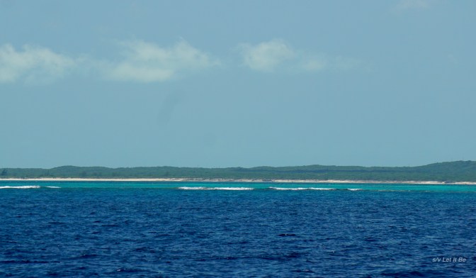
Breaking waves are often a “stop sign.”
Understanding the color of water dictates changing course, sometimes even when we are far from shore. These breakers are hundreds of feet from shore, but indicate shallows that we had to avoid.
On LIB, our favorite way of teaching inexperienced water readers is with the following rhyme:
Brown, brown, run aground,
White, white, you just might.
Green, green, in between,
Blue, blue, go on through.
While this isn’t Wordsworth, it is a handy way to remember what to look for here in the Bahamas or other areas where the water is clear and often shallow.

Enlarge this picture to see the shallows in the back.
Today we were exploring the NE area of Providenciales in LIB. The water under the keel as we motored through this channel varied between 9 and 5 feet. (We have a 3.5′ offset so we know how much water is between our lowest point and touching ground.) Slowly we moved forward but we did not go beyond the opening between these two protruding land pieces. The depth at the opening was back to 8 feet, but we could tell by the water color ahead that it would shallow very quickly. I was on the bow, wearing good polarized glasses, to confirm what we thought would become shallow water. About three or four boat lengths past where we turned around between the protruding rocks, the water was less than a foot deep.

Deep Bay, BVIs
This picture, taken from a hill above Deep Bay in the BVIs, shows the deep water in the far distance. Close to shore you can see the water is more green and more shallow. Midway out in the picture are the brown patches where there is too little water to boat across. You can also see a dark blue strip between two brown patches…. that narrow opening may be an opportunity to slip back out into the deep water beyond.

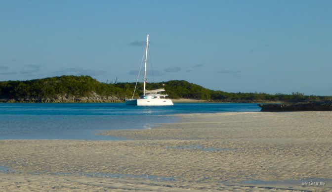
Warderick Wells Park
This final picture from Warderick Wells Park in the Exumas is stunning for it’s beauty but also teaches color. You can see the boats moored in an arc of deep, blue water. To the right is a white beach that is covered in water at high tide but much too shallow to enter. The inside of the crescent to the left shows lighter blue/green then white water; this area becomes a sand bar during low tide. Any boat that tries to cross it will be hard aground!
So there you have s a quick overview of reading water based on our experiences. Memorize the poem, don a good pair of polarized sunglasses, step to the bow of the boat and read away….
Is this similar to how you read water? Any tips you want to share in the comments? I would love to hear them.
As always, thank you for stopping by to read our blog. If you want to see what we are up to more often, check out our FB page: Let It Be, Helia 44. We would love to hear from you.

One thought on “Reading Without Words – Picture Sailing”